
XGRIDS Unveils Lixel L3 Scanner With 5 mm Accuracy and 4K HDR
The L3 upgrades XGRIDS’ handheld scanning hardware with larger camera sensors, built-in positioning, and a screen for use in the field.
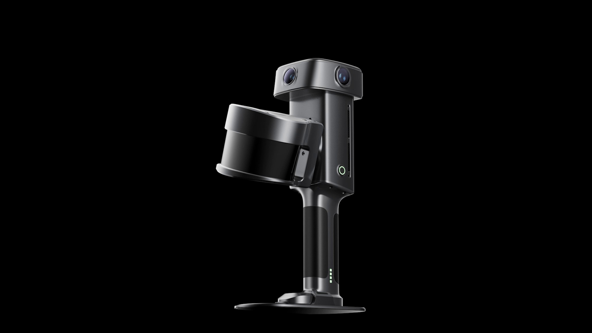
XGRIDS has introduced the Lixel L3 (opens in a new tab), a handheld 3D scanner with a claimed 5 mm post-processed relative accuracy, 4K HDR imaging, and integrated positioning and display hardware.
The upgrade from the Lixel L2 Pro (opens in a new tab) focuses on capture quality and field operation. The older model lists 1 cm post-processed relative accuracy. The L3 also moves from two 48-megapixel cameras with 1/2-inch sensors to three 50-megapixel cameras with larger 1/1.3-inch sensors.
The new 4K HDR system is designed to retain more detail in bright highlights and dark areas. That matters when a scan needs to capture how a place looks as well as its shape, especially in uneven lighting.
Better Capture for an Existing Workflow
Like other XGRIDS scanners, the L3 feeds three outputs from one capture. A point cloud records measured points, a textured mesh forms connected surfaces, and a Gaussian splat recreates the place as a lifelike scene you can move through.
That gives a captured building more than one use. A survey team can measure it, a designer can work with its surfaces, and a filmmaker can revisit the location digitally. XGRIDS’ Lixel CyberColor software handles the Gaussian splat reconstruction, with an Unreal Engine plugin for film workflows.
What 5 mm Accuracy Means
XGRIDS claims 5 mm relative accuracy for the post-processed point cloud. That describes measurements within the scan, rather than its position on a map.
The figure comes from a roughly 500-square-meter indoor test, comparing scan measurements with reference distances from a survey instrument. XGRIDS reports the result at approximately one standard deviation and says actual accuracy varies with the location and scanning path. The L2 Pro’s specification uses a different test description, so these published figures are not a controlled head-to-head comparison.
The scanner also produces a color point cloud during capture. XGRIDS rates that real-time output at 1 cm relative accuracy under laboratory conditions. The finer 5 mm figure requires processing afterward.
Built for Field Capture
Alongside its cameras, the L3 integrates RTK, a positioning system that uses satellite corrections, and a screen rated at up to 1,000 nits. XGRIDS also lists moving-object filtering to remove people and vehicles from the captured point cloud.
XGRIDS is offering demos and sample datasets (opens in a new tab) through its website. The product page does not list a public price or shipping date.
More from Capture & Create.
Browse all stories
World models · 2 min read
World Labs Previews Real-Time World Generation With Atlas
The AI model creates new views as you move, using reference images and earlier frames to keep the scene consistent.

AI 3D Creation · 2 min read
Meshy Launches Its New iPhone App
Powered by Meshy 7, the app turns photos and ideas into 3D models you can preview in your room and export for printing.
Gaussian splatting · 2 min read
PlayCanvas Releases SuperSplat 3.0 for Editing Larger 3D Captures
The update brings smoother navigation through heavy scenes, a brush that follows 3D surfaces, and color adjustments for selected parts of a capture.